![]()
<click on picture for full-size>
|
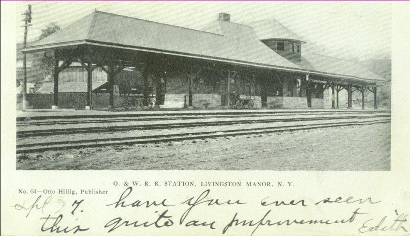
Included is a postcard from the collection of Vera Farrell. The image of the Livingston Manor O&W station is not unusual, but the message, and address on the reverse side, may be of interest to some. |
This Livingston Manor O&W station postcard from the Vera Farrell collection, dated 1905, was sent to "Miss Purvis". This most likely is Jane Purvis, who lived her last years in New York City. She was crippled with rheumatism during her later years and, judging by the message on the reverse side from "Edith", may not have ever returned to the Manor to see the "new" railroad station in her home town. The station was built in 1900. |
|
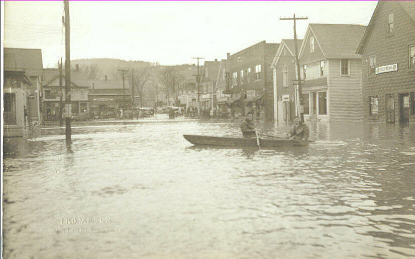
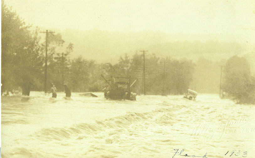
Vera Farrell's postcard collection contain many images of flooding in the Manor. Some images, though similar with other known postcard images, are new to me. The postcards have dates noted on the back, though some have question marks attached. This one is dated "1933?". |
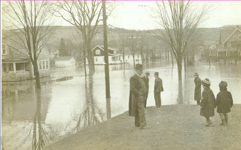
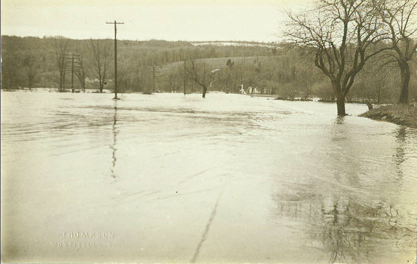
Another flood postcard from the Farrell
collection is again dated "1933?". This may or may not be the case.
River gauging stations, which kept records of the local streams flow,
were only located on the Little Beaverkill and further downstream on the
Beaverkill at Cook's Falls in 1933. The gauging station on the
Willowemoc didn't start recording information until 1937.
The major flooding event at the Manor for
1933 occurred on August 24th. This image could not be that event for
there is no foliage on the trees. There also appears to be residual snow
on the hillside in the background. Snow has been known to linger at the
Manor, but probably not in August. It no doubt is an early spring flood.
Records do show that there was a high-water event on the Little
Beaverkill on April 17th of that year, but the volume of water on the
Little Beaverkill was considerably less than what was recorded during
the later summer's flood.
|
|
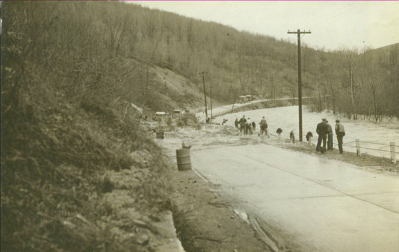
This postcard has a date written on the
back; 1933, without the question mark. Again, snow can be seen on the hill
in the background. The location is unknown but notice the misshapen tree
near the center of the image, in the midst of the flood.
Postcard photographs, when the location of
the image is unidentified on the card, offers a challenge in
attempts to finding the image's locality. The flood photographs from the
postcards of Vera Farrell, in fact, may not even be from the around the
Manor. Photographic evidence, however, proves otherwise.
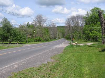
Geographic landmarks of this image show a
long, broad river valley with the flow of the flood current, from left
to right, suggesting the river is on the left side of the photo. Other
features include the poles. The taller electric poles suggest there is a
road somewhere underneath the floodwaters. The first three of these
electric poles, nearest the photographer, appear to follow one side of
the inundated highway, and then, in the distance, cross the highway and
continue down the valley.
The other poles, with the numerous crossarms,
suggest being telegraph poles which are often associated with railroad
routes. In this broad expanse of valley depicted in the image, only two
structures are seen, the white structures at the distant end of the
valley and the barn-like structure located on the lower distant hillside
to the left.
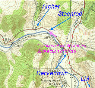
In the Manor area, only two localities would
have a highway traversing the center a broad, flat river valley; the
valley of the Little Beaverkill above Morsston and the Willowemoc Valley
above Deckertown, between Roscoe and Livingston Manor.
|
The electric poles are the key in identifying the Farrell flood post card. At the edge of the flats above Deckertown, where the Catskill Flyfishing Center is located, the electric poles can be seen in the same configuration as those in the postcard; three on the left side of the highway (old Route 17) before the electric line crosses over to the right side. Seventy-five years may be a long time for poles to survive, so they may not be the original poles. However, when the electric company changes poles they usually set the new pole alongside the one that is to be replaced, and simply transfer the wires. Even if the poles that are seen in the current image are not the original poles seen in the flood postcard, their locations is most likely generally the same.
|
|
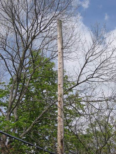
The telegraph poles also offer evidence of the flood postcard's locality. Many of these poles still exist, though without the numerous cross-arms. They follow along the river's bank, today carrying the telephone cable. Since the vegatation has grown up around them, most of the surviving poles are not noticed from the road. On close inspection of the poles themselves, though, you can see that at one time they carried numerous cross-arms; the rounded poles were chiseled flat where the cross-arms were located. Its hard to believe that poles can survive the elements for over seventy-five years; proof of the durability of creosote. |
Most of the poles shown in the image from
the Farrell flood-postcard may have survived but that is not the case
for some of the buildings. Buildings, and their location as shown in
a early photograph, help identify the location of the image. When the
building no longer exists, though, the photo's location becomes more
uncertain.
The white house and other structures that
appear near the center of the image, within the flooded valley, no
longer exist. The small farm was then known as the old Steenrod place,
but during the time of this flood it was owned by Isaac Richards. Today,
a mobile-home park is now located at the site; those familiar with the
recent floods know that these residents receive some of the worst
flooding in the area. No doubt the old Steenrod homestead also suffered
mightily during these episodes of inundation.
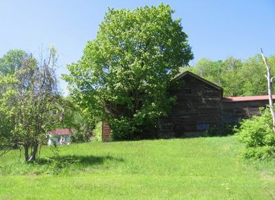
On the distant hillside, towards the left of
the image, there appears to be a barn with another structure behind it.
This is the location of what was then called as the Archer place, but
was owned during the time of this flood by Mrs. Helen Shurr. These
buildings are still in existence today, on old Route 17 where Bascomb
Brook empties into the Willowemoc.
|
|
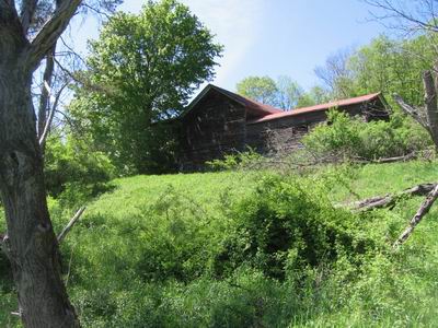
The barn that appears in the flood postcard has been altered somewhat since that particular flood, an addtion being added. The two-story, center portion of this building is the original barn. |
Theodore F. Archer bought the William Rose
farm in 1905. Archer was an auctioneer from Long Island and used the
farm as a summer retreat. He and his wife eventually spent much of their
time in the Manor area, starting a highly successful real-estate agency
and purchased many of the old farms at the Manor. One farm, the old
Vernoy farm, overlooking the village, he liked so much, that he sold the
Rose place during the late twenties and established a summer boarding
house on the hillside farm.
To the left of the barn, as can be seen in
this photograph, is the Rose-Archer farm house. This is the building
that appears behind the barn on the postcard.
|
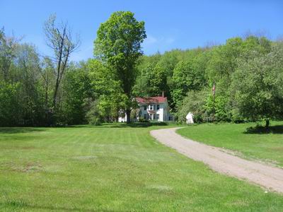
|
The William Rose - T.F. Archer
farmhouse.
I am currently trying to figure out which William Rose
this house belonged to. I think it was the home of William,
brother of my great great grandfather John Rose. This William went to
Ogemaw Co, Mich about 1870.
There is a possibility it's William, son of Lawrence.
This William is interred at Methodist Church cemetery. (Lawrence being
the oldest brother of my 2x grandfather.
evelyn
|
This is a Hillig Studio postcard, and as can be seen, the date is scribbled on the image as 1933. This would be the August 24th event. Again, the location is not known (as of yet) but notice the tree on the left, near where the rescuers (brave souls) are wading. It appears to be the same misshapen tree from the earlier flood postcard. With a little imagination between the two images, you can line up the electric and telephone poles in the background to be in the proper position as the location of the photographer is different. For this flood, the photographer must be standing on the high ground near the apple tree on the right of the earlier image. Notice the vehicle on the right.
|
|
Another Hillig Studio postcard, possibly the same vehicle in the earlier postcard. A telephone pole can be faintly seen in the background, to the left of the truck. |
|
|
A Thompson Studio postcard, as were the some of the earlier posted cards, with a date noted on the back as "1933?". Judging by the concrete highway, it maybe old Route 17, and by the landmarks, it appears to be on the road between Roscoe and Livingston Manor, just around the corner from the Bennett homesteads. A retaining wall is in place but did little to stop the landslide and plugging up the road. |
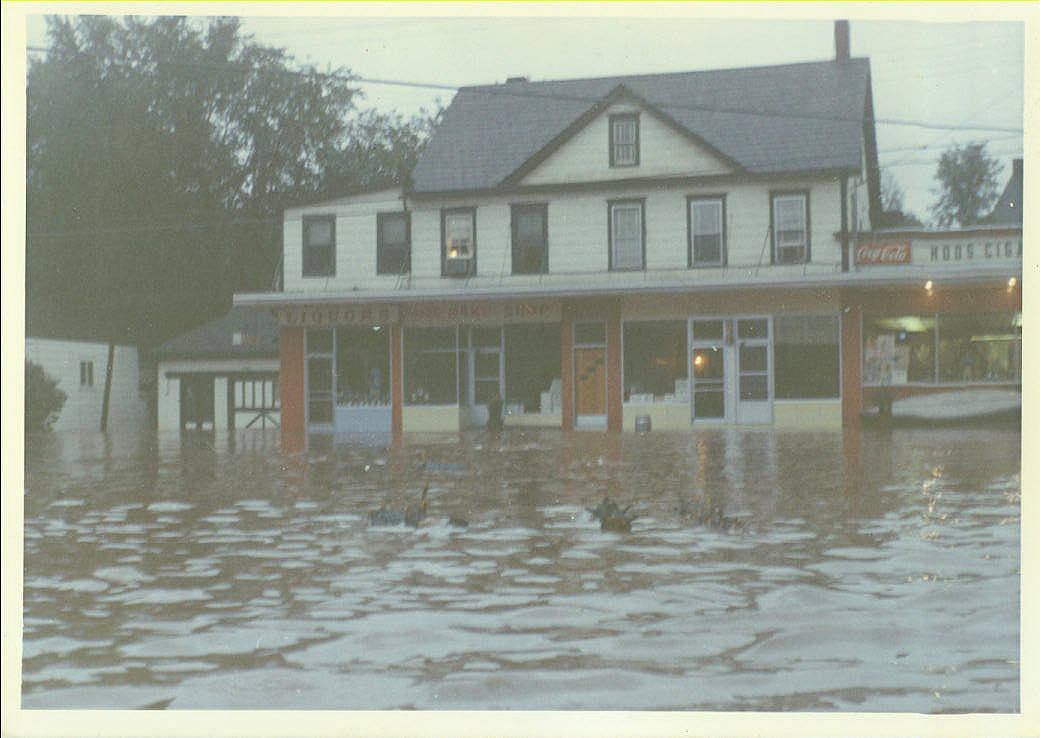
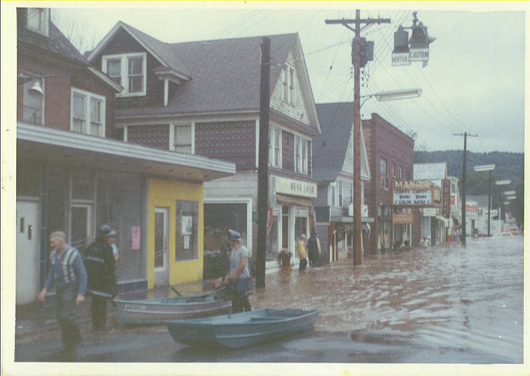
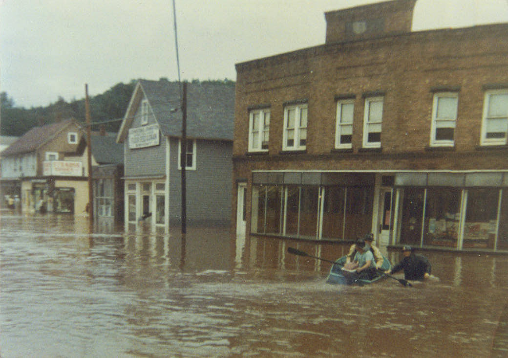
During the 1969 flood, considered the worst to hit the Manor until two years ago, an unknown photographer, with what appears to be an instamatic camera, floated along Main Street snapping images. A series of images are associated with this photographer. |
|
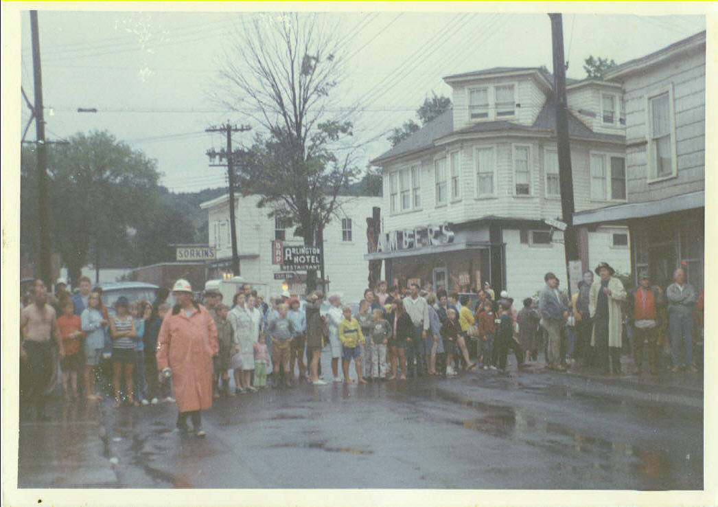
For those of us not directly effected by flood waters, flooding is a spectator sport. |
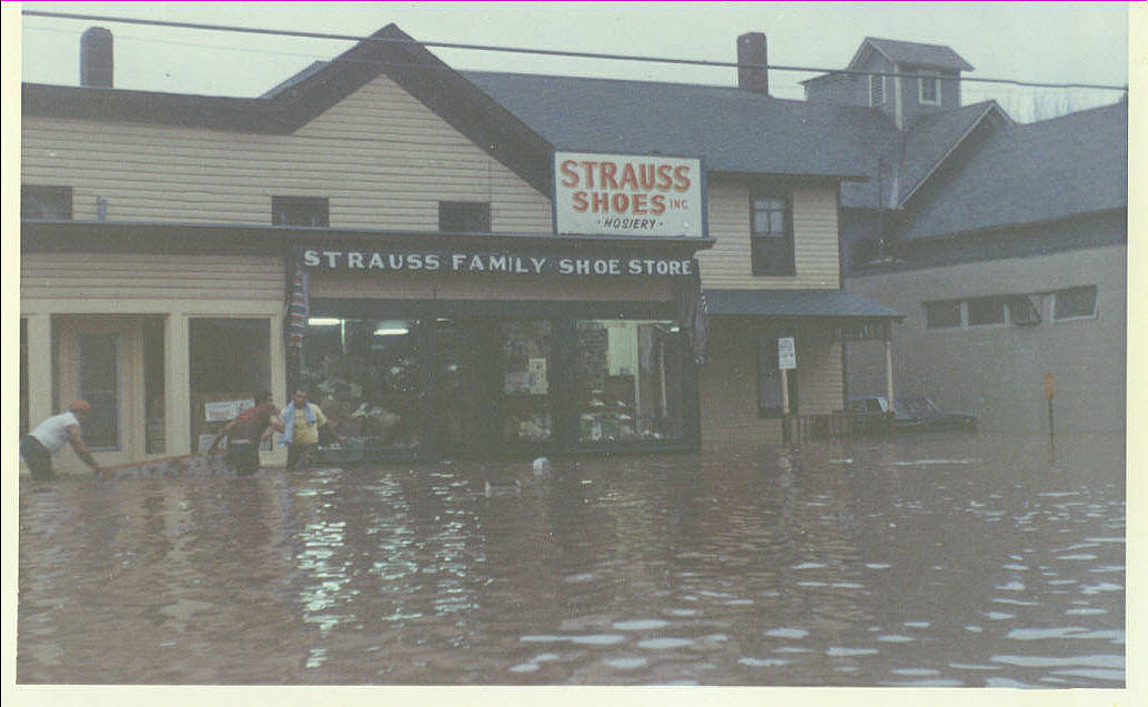
As seen in the window of the Strauss building, the electricity remained on during the flood of 1969. The more recent flood of 2005, someone had the bright idea of cutting the electricity into the village during the high water, adding to the misery to many more than just the usual flood victims as now sump pumps were inoperable and many more basements were filled with water. During the more recent flood, 2006, the electricity remained on. |
|
|
Manor trivial question;
What was the movie playing at the Livingston
Manor Theater at the time of the July flood of 1969?
|
|
Fortunately for the Johnston family, the family business had already ceased operations, as noted by the empty windows. The flood, though, probably hastened the demise of the building which was torn down the next year. |
|
| Comments by Fred | |