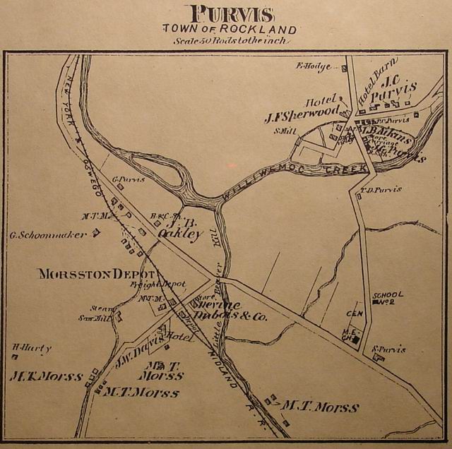
 click
for larger picture
click
for larger picture<click on picture for large size>
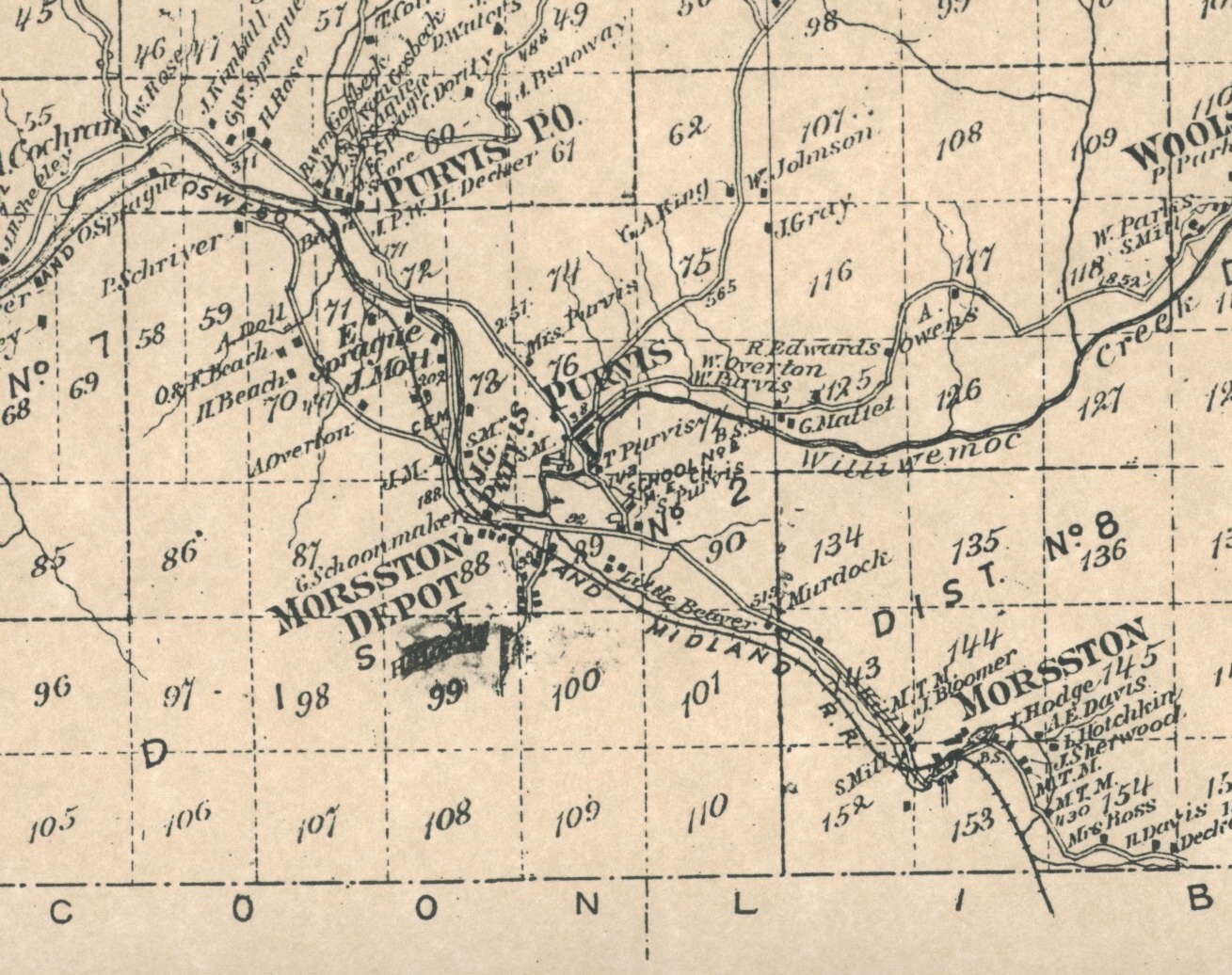
Many questions arise after looking at the Beers 1875 map of Purvis, Woolseyville and DeBruce
click
for larger picture
Beers 1875 map of Purvis

After the Yahoo discussions about Little Ireland (see below) and a couple of
questions from others that are following the group as to "where was Little
Ireland" I thought I would get the 1875 Beers map out and put up the map
where Little Ireland was. To my surprise the area was considerably larger than I
thought. I always thought it was just the little valley up by the Body's and
Woods where my Father was a member of the Little Ireland Hunting Club.
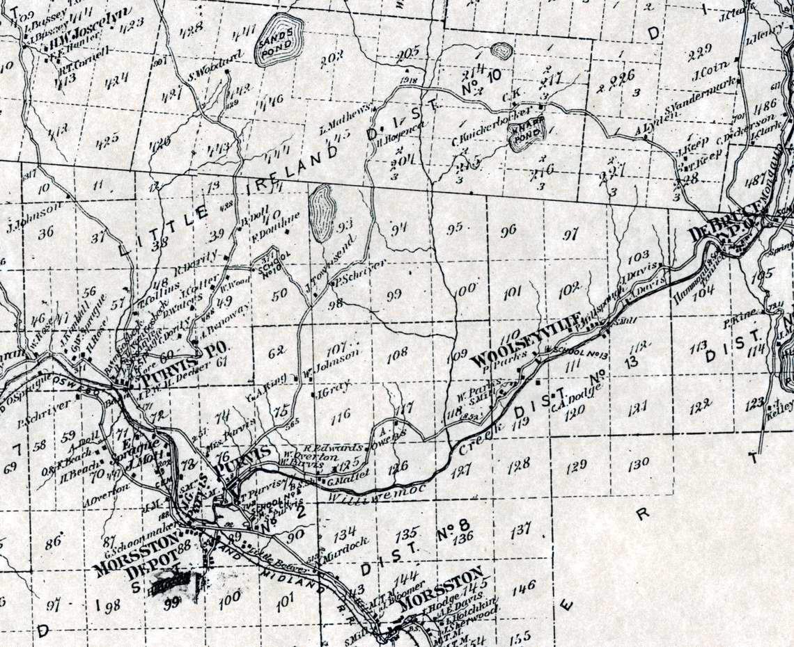
Little Ireland -<click picture for full size>
There was a school district #10 that covered the area from Purvis PO (Deckertown), Grooville and almost to DeBruce. Maybe this why the census-taker took so long.
The school was on the road that comes out on the White Roe Lake road by Trojan Lake. Does anyone know if there is anything left of the site or where it was. (A picture would be great!!!)
Emails about Little Ireland
1. Is there a old land map of LM? I have a place on Little Ireland rd
and would like any info on the area. I am at the Crossroad in the
cottage community. Also, any info on the old Irish school house that
was ones there as well would be appreciated, thanks
2. "Felix Dougherty died Tuesday morning at the home of his daughter,
Mrs A.R. Purvis, aged about 94 years.
"Deceased was born in the county of Tyron, Ireland. About 51 years
ago he came to the Town of Rockland. He bought a piece of land in
Little Ireland, then a wilderness almost unbroken and made for
himself and family a neat and comfortable home. He had for his
neighbors Davis Waters, Frank Donohue and Bernard Cotter, all Irish
immigrants which gave the place its name."
December 16, 1903.
3. Warm weather starts up here around July 12th. Fall begins on the 13th.
You may already know, but our moderator, Harold, has also created a
Livingston Manor history site. You can find it on this homepage by
going down to the group e-mail location and click on
http://hvanaken.com/lm/index.htm
. Here, you'll see that he has
posted the early census' from the Town of Rockland. If you open up
page 8 of the 1850 census, you'll see all of the residents who were
living at Little Ireland at the time.
Dougherty, Watters, McHadden, Rose, Cotter and Reed would be the
names of those who lived there then. James Sprague's residence was
located at Deckertown, maybe the current Smith house. Notice the
birthplaces of these people.
4. In the 1860 census, the tour of Little Ireland by Thomas Grant, the
enumerator, begins on page 200. On page 199, the Whitmores and
Hogancamps were probably from the White Roe to Grooville area, and I
don't know where Hendrickson was located, but Frances Donohue was
definately from Little Ireland.
William Waters was not there in 1850. Could he had been David's
brother? There are now two Rose families instead of one and John
Crippen has arrived from Pennsylvania.
William Wood and family are interesting because they may be the
ancestors of Lena Wood. Her farm was just down the road from the
intersection, across from George Boddy's. I believe one of George's
sons, or grandson now lives at the old Wood place.
Thomas Grant spent the afternoon of June 20, 1860 with the Little
Ireland folks, ending the day finding John Maffit and Peter Appley,
whose residences I still am not able to find. Joseph Laraway, on page
201, is definately from Beaverkill and worked, along with his sons,
at the Babcock tannery.
The Sprague families are the Lew Beach Spragues, not the Deckertown
Spragues, so Mr. Grant probably started June 21st at Lew Beach
because he bypassed the Beaverkill area and the Davidson family
between Beaverkill and Lew Beach. Or maybe John Davidson wasn't home
when Grant visited; he was in the Manor building the Jacktown covered
bridge that summer, but then, that's another story.
5. On August 22nd, 1870, Jeremiah Bridges, census enumerator, visited
the folks up at Little Ireland. His endeavors can be found on page 10
of the 1870 census from the Town of Rockland.
Since the Winner (?) name is associated with the Willowemoc valley
area, it looks like his first visit of the day was with the Dougherty
family, the old farm at the crest of the hill along the road that
leads from Deckertown, currently the Don Fries place.
As he left at the end of the day, he traveled down what is now the
Elm Hollow Road and visited the Woodard farm (page 11), later to
become the summer residence of Darren McGavern, the movie and
television actor. Remember "Riverboat", anyone?
6. Thanks Goeff. Now, if all this were only true. What is somewhat
curious is the time Jeremiah spent enumerating the Little Ireland
area in 1870. It may have been only one day. Throughout the census
for the rest of the township, he covered many families that
encompassed much larger areas in one day, but on the 22nd of August,
it appears that he may have only visited about 10 families. Why the
slowdown? Of course, I have my theories;
"Getting a late start that fine August day, Jeremiah trudged up the
steep wooded trail towards Little Ireland. Though normally on the
road at dawn, Jeremiah's stay at Alphebet Decker's the night before
lasted longer than he had intended. At Decker's store and post
office, being the local meeting place, Jeremiah was cause for
celebration and all the locals, the Spragues and Motts, showed up to
meet him. Jeremiah was enthralled with their stories about their
Civil War adventures and rafting lumber down the Delaware, so much so
that early the evening sooned turned into early morning. Of course,
local drink, which Jeremiah wasn't accustomed to, enhanced the
stories but certainly didn't give our enumerator a sunny disposition
on this day. As he finally made it to the first clearing at the crest
of the hill, the bright sun burned down on his already throbbing
head. 'Oooohh, I got to sit down and take a break.'........."
Or possibly, "Jeremiah wound his way up the steep, heavily wooded
Little Ireland trail. As he crested the hill and the first clearing,
he was awestruck at the panorama before him. There, in the early
morning sun, lie the punchbowl valley of Little Ireland, so isolated
that it was still untouched by the area lumberman and tanners. In
this heavily forested wilderness, he could see all ten little
clearings that these early settlers opened up for their small farms.
And the people. All fine, Irish immigrants, who opened their homes to
Jeremiah and insisted on sharing their provisions, so greatful they
were for the company and being recognized by their new, adopted
homeland. Here, as Jeremiah listened to the immigrants stories, he
learned of people and places so far away, places he never knew
existed. He would have stayed longer if he could, but he needed to be
back in Liberty by..........".
Amazing, how I started this and it has grown. As far as the school
goes. I was told by Lena Woods that it had burned down in 1924 or
29. You can still see the foundation covered by trees and ground
growth. That is what started this whole curiosity. I am still trying
to find out who first owned my property and how it turned into a
cottage community. According to some records I found a house was
built on it (by Who) around 1930 then the cottages started going up
in 38-42 We are now a coop at the intersection of Little Ireland Rd
and what was the Crossroad
Chris