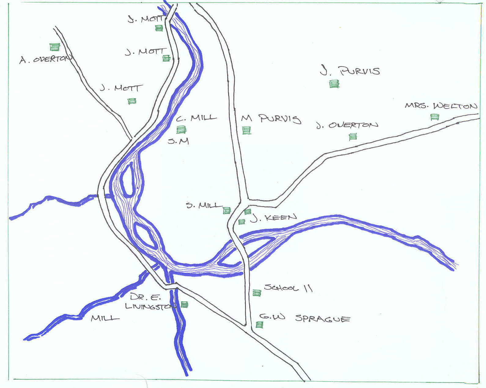
Lot 89 - The Livingston Farm
August 20, 2006
Under the Hardenburgh Patent scheme of parcel division, most of present
day Livingston Manor lies within the bounds of what is known as lot 89 of
Great Lot number four. Included on the Photos site, in the "Maps" album, are
images of a map from a survey made in 1919 by Lawrence McGrath, probably for
Charles Victor Livingston. The quality of the maps are less than ideal for
the copies were made on blue paper, similar to a photographic negative, and
much of the notations did not print very well. The maps were also damaged by
flood waters, a casualty of the flood of '06, adding to the difficulty of
deciphering the map's information.
First off, it must be noted that this is most likely the original map of the
Edward Livingston lot, used during the litigation by his nephew's son, from
which Josephine McGrath's sketch map came from
Wayne came in custody of that map and it is now posted on the
livingstonmanor.net site. The original, though, gives us additional
information that may be of interest.
The notations along the property lines that bound the perimeter of the lot
are an example. The southern boundary is listed as "South 66 degrees 20
minutes East in 1790." Alongside this is the bearing that McGrath set during
his resurvey; "South 58 degrees 35 minutes East in 1919." These dates can be
found on not only the other boundary lines of lot 89, but also on the
neighboring lots. One would have to conclude that the original survey of the
Livingston Manor area was done in 1790.
fred
August 21, 2006
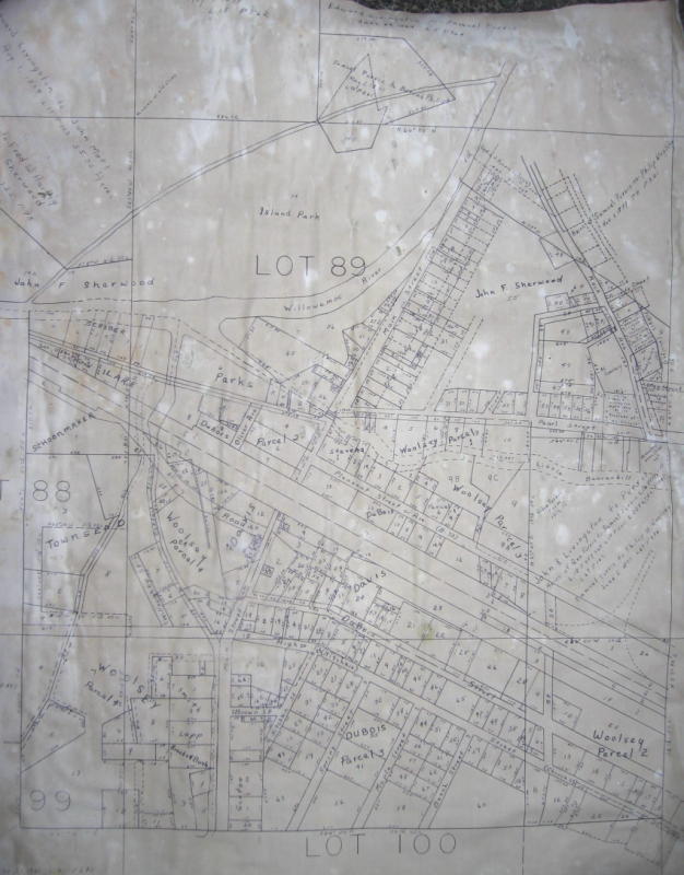
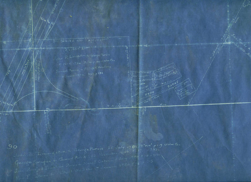
Lot 90, which is at the bottom of the drawing and adjoins lot 89 (the greater portion of the Edward Livingston farm) along its eastern boundary provides much information related to the history of the deed changeovers on the property. Since the image of "Lot 89" on the "Photos" site is not entirely clear, let me relay the information in its entirety below;
John R. Livingston to George Purvis, 25 July, 1792, B "MM" p.119
Ulster Co.
George Sprague to Samuel Purvis, 22 November, 1856, B 37 p. 393
Jane Purvis & Emmalissa Purvis to Mary E. Oatman, 7 January, 1880, B
78 p. 312
Mary E. Oatman to Philip H. Woolsey, 7 January, 1880, B 78 p. 315
John R. Livingston, according to the Sliter documents, would be Edward's father. We have always associated the Purvis family with Edward, but here we can see that the first contact between the two families was between George Purvis, the immigrant, and Edward's father, who in the 1790's started to develope his families land grant in the Hardenburgh Patent.
fred
August 22
Thanks for posting this additional information! I had studied the website survey map, but as you said, these notations are not visible. The first transfer, “John R. Livingston to George Purvis, 25 July, 1792, B "MM" p.119 Ulster Co.” is the earliest actual (documented) date we have for George the Immigrant. He would have been in the U.S. for some amount of time prior to this purchase, between when he stepped off the boat and traveled to this part of NY one can assume. It also makes sense that the transaction would have been between Edward Livingston’s father and George Purvis since Edward was born c.1798. George lived in Neversink at the 1800 census, but with this deed we now know he lived there in 1792.
In looking at the ‘Purvis 1875 Map’, Lot 90 is shown to the right of Lot 89, as the survey map is a different orientation. All our discussions last year in the LM group about the original Purvis homestead centered around where the Purvis and other-surname-descendant families were shown living on the 1875 map, that is on Lot 76 (above Lot 89) Lot 77 (above Lot 90) and Lot 125 (to the right of Lot 77). So, how did the acquisition of these additional 3 lots come about, and when? Were these additional lots bought by George the Immigrant, or by his descendants?
And another mystery: On the 1875 map there is no house shown on Lot 90 at all…if the map is enlarged it’s evident the names that cross it belong to squares, representing houses, on other lots. What was Lot 90 being used for in 1875? I don’t know the topography...was all of Lot 90 farm fields? To which farmhouse square(s) did these fields belong (on the 1875 map)? I also see there are no house squares shown on Lot 77, which is above Lot 90 and between Lots 76 and 125, where the Purvis and other descendant families lived.
The second transaction, “George Sprague to Samuel Purvis, 22 November, 1856, B 37 p. 393”, occurred two generations after George the Immigrant bought Lot 90 from John Livingston. This would indicate the title to Lot 90 passed through inheritance. We believe George the Immigrant died before the 1830 census, since Elizabeth Purvis, age 70-79, is head of household at that date and George is not found. In the 1850 census George Sprague (age 48) and his wife Jane Purvis (age 40) lived next door to Manly Purvis (age 43). Jane is thought to have been Manly’s sister. Manly was the son of William Purvis and grandson of George the Immigrant. William was the second son of the Immigrant. The eldest son, George Jr., had moved years before to Seneca County and later to Ohio.
On the Sullivan County/Rockland 1829 map, “Lot 90” is split in half and shown as a half-sized Lot 90 with the other half labeled Lot 91. Perhaps Jane inherited the (half) Lot 90 and Manly inherited the (half) Lot 91 as they are identified on the 1829 map (perhaps the lot was split and re-numbered after George’s death, at least on that map.) In the 1830 census widow Elizabeth Purvis has individuals in her household of the age of Manly and Jane; their father William is not found in the census after 1810. It is likely both Manly and Jane were minors at the time of George the Immigrant’s death; their father had died earlier, before 1820. When they reached majority, they would have inherited their father William’s share of George the Immigrant’s estate. This is my theory on why George Sprague (the deed would be from Jane also) was deeding this land that adjoined Lot 89.
So where did George the Immigrant build his house? Was it on Lot 90 or on one of the nearby lots where his descendants lived in 1875? I guess we’d have to look at Book MM in Kingston, or at least the grantor index, to find out who John Livingston deeded lots 76, 77, 125 and perhaps other lots to. Could it have been to George the Immigrant?
Janet Mackie
August 23
By scanning the sections of these maps, I was able to sharpen the image somewhat and though still not perfect, it is better than the original.
fred
August 23, 2006
by George Purvis. Located on the southeast corner of Lot 89 is a
thirteen and a half acre parcel that has the following;
John R. Livingston to George Purvis, 17 November, 1796, B. 16 p. 96
Ulster Co.
Samuel Purvis to Philip H. Woolsey, 2 June, 1873, B. 67 p. 296
This lot covered the area between the railroad tracks to what would eventually become Pearl Street, the intersection of Pearl Street and Rock Avenue being the northeast corner of the lot. It is on this lot where P.H. Woolsey built his home, across from that intersection. This thirteen acre lot coupled with Lot 90, also originally a George Purvis lot, would later be known as the Woolsey farm. Could this have been the original Purvis homestead? My guess is that it was. If the copy of the detail map (on the "Photos" site) is clear enough, notice the "old house" located along the boundary of lots 90 and 89.
The information supplied by this McGrath
survey map also calls into question George Purvis's relationship with John
R. Livingston. It is well known that George's son, Samuel Purvis, and
family were linked with Edward Livingston, John R.'s son; some accounts
calling Purvis the caretaker of the Livingston household. But little, if
anything, has ever been mentioned of the relationship between the fathers.
Could it be that George Purvis became the land agent for the Livingston
family? Land agents for these non-resident landowners, such as the
Livingstons, would be responsible for enticing immigrants to purchase into
their clients real-estate holdings, in this case Great Lot Four, often
greeting these newcomers as they departed their ship at the port of New
York. If this is the case, than the Purvis connection concerning the
history and development of Livingston Manor is even more understated than
we will probably ever know.
fred
August 24, 2006
August 24, 2006
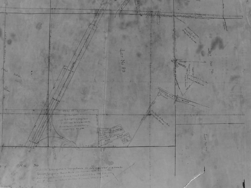
Notice on the upper left of this lot, below the Little Beaverkill, where the lot is called the "Widow Purvis Farm". Since Samuel Purvis sold the lot to Philip H. Woolsey June 2 , 1873, showing that Samuel Purvis was still alive, the "Widow Purvis" mentioned must be the wife of George Purvis.
Also listed with the deed transfers is "Heirs of Geo. Purvis to Samuel Purvis L. 10 P. 150, 157...." The "L" and "P" represent the book in which the deed is filed at the county clerk's office, L being the book liber number and P meaning the page. The date is not recorded on this map, but "L. 10 P. 150" was probably recorded during the late fall of 1833 or the winter of 1834, giving an approximate date of death for George Purvis.
fred
August 28, 2006
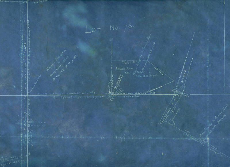
One map is worth a thousand words. Lawrence McGrath's survey map of the
Edward Livingston farm also reveals more of the historical development of
Livingston Manor outside of the farm property itself.Lot No. 70 is directly
north of the Livingston farm, and includes the area that became the
community of Purvis. The detail of this portion of McGrath's map can be
found in the "Photos" section and also posted on Harold's Livingston Manor
Home site.
The common boundary line between Lots 89 and 70 can be seen crossing the
Willowemoc at the bridge crossing. Whether this is the Jacktown covered
bridge or the iron bridge that replaced the wooden structure in 1913 is not
made known on the map. Following this boundary line, it also crosses the
mill race. It is here that Lot No. 70 was subdivided, as a division property
line can be seen next to the raceway. Of the two lots formed, the lot on the
right was slightly larger. The deed transfer for this portion of Lot 70 was;
"Edward Livingston to Samuel Purvis, 28 June, 1824, B. 5, p. 324"
The remaining part of the lot was transferred from Edward Livingston later,
as noted on the map;
"Edward Livingston to Thos. & Henry Mott, 4 August, 1839, B. 15, p 362"
Neighboring lots 73 and 88 were also conveyed by Edward Livingston, this
time to John Mott, in 1834. All this information shows that Edward
Livingston was now in legal control of his family's land holdings in this
portion of the Hardenburgh Patent by 1824. It verifies what we already knew.
What is interesting, though, is the trapazoidal shaped lot within Lot 70.
This would be in the area where the "business district" of Purvis, and later
Jacktown, was located. A blacksmith shop, a carriage shop, and mercantile
store, as may have also been the oringinal mills, were all located here when
Purvis was the center of the community. As shown on the map, this lot was
separated from Samuel Purvis's property;
"Samuel Purvis to Burrass Phillips, 3 May, 1833, B. 9, p. 461"
So the question becomes who is Burrass Phillips, what was his role in the
development of Livingston Manor and whatever became of him?
Fred