by Fred Fries
![]()
|
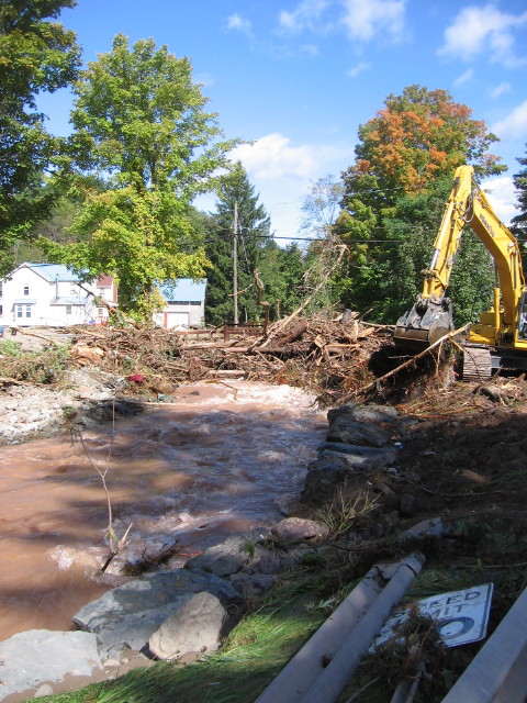
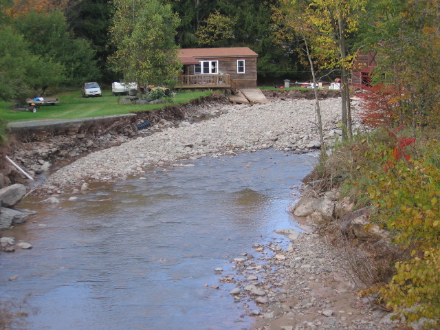
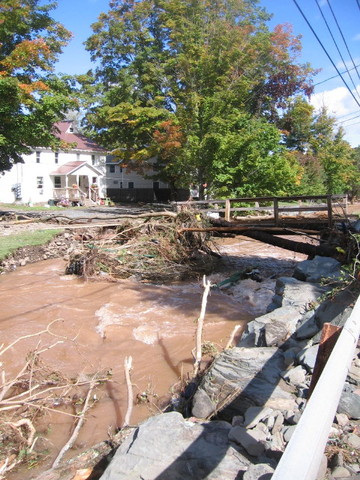
Floodwaters again visited Livingston Manor on Tuesday, causing damage to roadways and bridges, invading downtown shops and creating serious havoc to residences along the Shandelee Road. Rainfall, estimated to measure five and one half inches, fell heavily for a period of only twelve hours, suddenly filling up creek beds that had just previously been next to bone dry with the summer's drought with an angry torrent. The major culprit this time for the town's grief is the Cattail Brook.
Coming off Shandelee in raging fashion, the Cattail cut
into its banks just after crossing beneath the Shandelee Road bridge near the
old Scudder farm, toppling trees into the current and sweeping them
downstream. The river channel became wider as soil and rocks fell into the
floodwaters and was carried away. Driveways that were located next to the
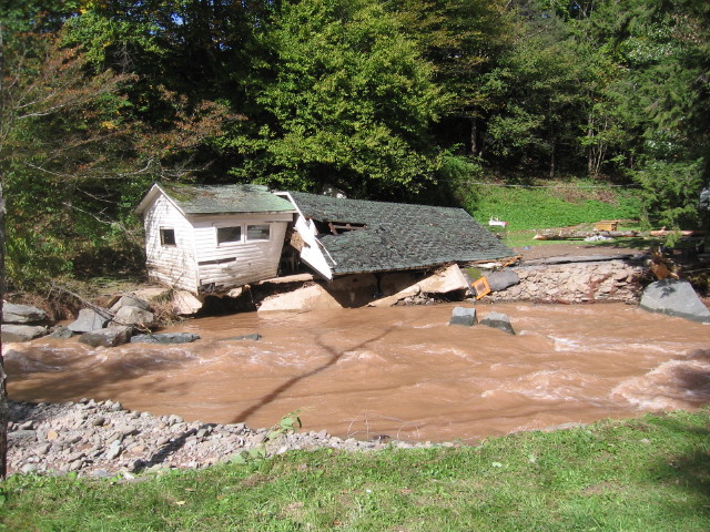
brook were washed away. Two houses were undermined by the current, leaving one
half of each of these structures now perilously dangling over the altercated
river channel. They both are condemned. As all of the debris became entangled
upon the bridge crossing the Cattail Brook across from the county highway
barn, the bridge was pushed off its abutments, falling into the stream, and
along with the rest of the debris, was carried downstream by the raging
current. Large rocks, placed along the river bank to protect the abutments
were tossed around in the current and displaced downstream.
At the next bridge, the private bridge across from the
Fontana residence, the concoction of tree parts and pieces of the upper bridge
again must have jammed, causing the river to rise out of its banks and onto
the Shandelee Road. Once the water is out of the channel of the Cattail, it
follows the highway smack into the center of town, ripping up the pavement of
driveways and side streets and damaging sidewalks. Water got into the
firehouse and amblance corps building.
Leaving the remains of the upper bridge behind, the debris
of trees passed through the private bridge, only to jam up again on the Finch
Street bridge, building up a pile of broken limbs and trunks high into the
air. Again, flood waters rose out of the channel and was sent down Main Street
into the center of town. The bridge survived.
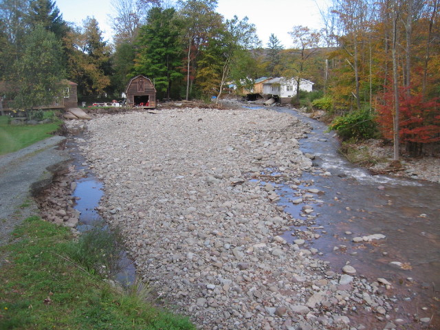
The muddy waters entered the usual Main Street shops; the Strauss building, the Siegel building, the Brooks building and the concrete building. Buildings that have basements needed to have the firemen come to pump them out. The Pearl Street buildings of Shaver's and the Friedman's received water. The parking lot for the Sunoco convenience store was caked with sand bars. At the next bridge, the private bridge across from the Fontana residence, the concoction of tree parts and pieces of the upper bridge again must have jammed, causing the river to rise out of its banks and onto the Shandelee Road. Once the water is out of the channel of the Cattail, it follows the highway smack into the center of town, ripping up the pavement of driveways and side streets and damaging sidewalks. Water got into the firehouse and ambulance corps building. Leaving the remains of the upper bridge behind, the debris of trees passed through the private bridge, only to jam up again on the Finch Street bridge, building up a pile of broken limbs and trunks high into the air. Again, flood waters rose out of the channel and was sent down Main Street into the center of town. The bridge survived. The muddy waters entered the usual Main Street shops; the Strauss building, the Siegel building, the Brooks building and the concrete building. Buildings that have basements needed to have the firemen come to pump them out. The Pearl Street buildings of Shaver's and the Friedman's received water. The parking lot for the Sunoco convenience store was caked with sand bars.
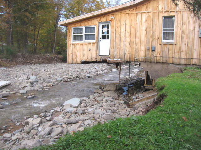
The old Simpson garage along the Cattail Brook; or what remains of it Being damaged on numerous occasions from previous flooding, extensive work had been done to shore up the river bank underneath the building. Unfortunately, it was no match for the river this time
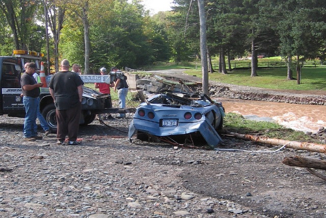
Being undermined by the alteration of the Cattail Brook's channel, the floor of the garage portion of the Bear house fell away from the building, dropping the owner's Corvette into the flood waters. It was pulled out of the river about one hundred yards downstream.
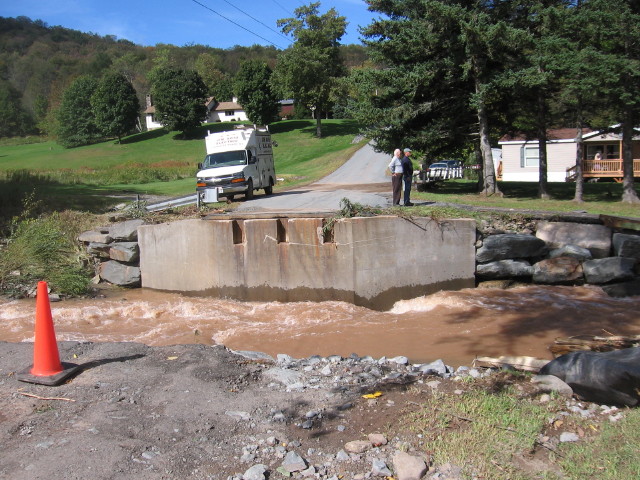
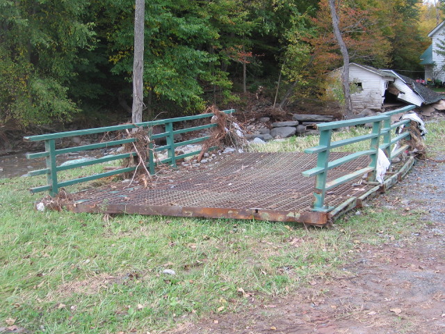
The upper bridge, across from the county highway department, is gone, pieces of it strewn about the river channel downstream. It was just rebuilt last year.
Last week's storm was unusual that it flooded the Manor in two episodes. What has been estimated to be as much as seven inches of rainfall falling on Shandelee within a twelve hour period, caused the Cattail Brook to quickly rise and wash away trees and its river banks and to overflow onto upper Main Street. There it followed the street, flooding the downtown section of the village and washing away pavement and items not secured down along its path.
As quickly as the Cattail rose, he
also subsided, leaving behind a mile long stretch of destruction. Then,
the Little Beaverkill rose onto the lower streets of the Manor, again
sending flood waters, this time from a different source, into the center
of town.
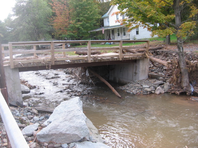
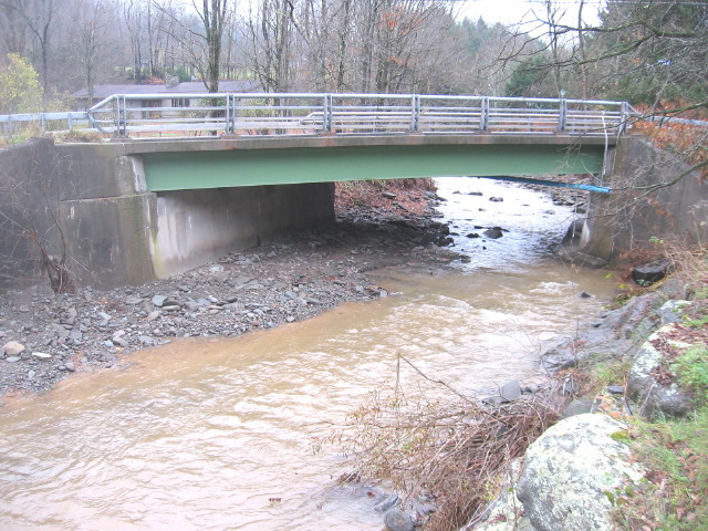
Where the Cattail crosses under
the Shandelee Road bridge on the upper end of town begins the scene of
destruction this normally shallow brook created. The width of the
channel doubled in size at this location, undermining buildings and
leaving behind a field of gravel and boulders.
With driveways and lawns washed
away by the Cattail's raging currents, houses that were once set back
away from this small brook have now become uncomfortably positioned on
the riverbank's edge.
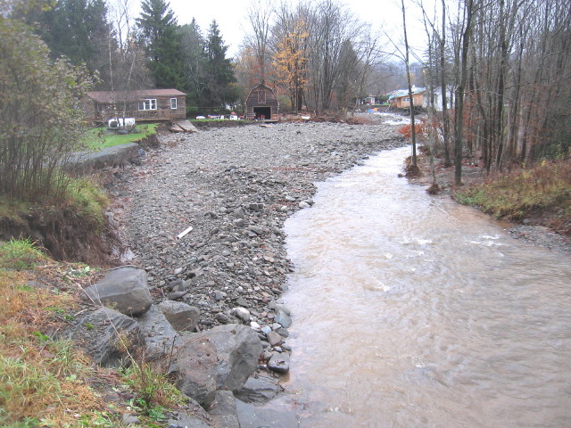
After the flood waters made the
bend and widened the Cattail Brook's channel, the rapids switched its
eroding force to the eastern side of the river, along the riverbank
directly behind a series of residences. Shore-line trees that were
already precariously hanging onto the banks due to damage from past
floods did little to protect the residences' back lawns. trees and lawns
being washed away. Floodwaters now slammed against exposed foundation
walls, undermining the footings causing the walls to collapse. Floors
gave way from the portions of the dangling structures spilling its
contents into the river.
The first obstacle for this
cauldron of floating debris was the upper Finch Street bridge. The
bridge was a survivor from the 2006 flood, the first Cattail flood since
the 1930's, though both approaches were heavily damaged. Subsequent work
since that more recent flood improved the bridge abutments. These new
abutments survived this time around, seemingly unharmed, but the
steel-deck bridge itself was pushed off, falling into the floodwaters
and transported downstream by the currents. The main portion of the
wrecked bridge lodged into the Cattail's channel just before the private
bridge, which along with the debris of trees, backed-up the floodwaters.
Now overflowing onto both banks, the river now ran out of its channel
and into town.
The private bridge over the
Cattail, completely rebuilt after the 2006 flood, survived, though
heavily damaged on the back side of its abutments.
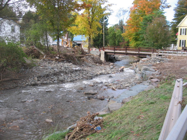
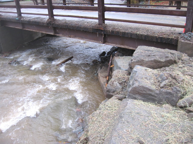
The lower Finch Street bridge
survived, though was the scene of a massive pileup of debris. It was
immediately dislodged by Sullivan County highway department and, as this
photograph shows, within a week had the banks shored up again.
Due to the jam at the lower Finch
Street bridge, the river washed up onto and destroyed the lawn of the
old Kennigeser house, flowed over Finch Street, creating an impassable
channel in the highway, and washed down into the Tompkins house and
garage.
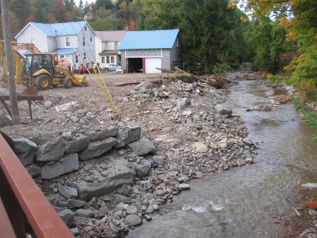
With the floodwaters from the
Cattail now running along the upper portion of Main Street, water ran
through the mill property, washing over lawns and running through
buildings on Main Street, Riverside Drive and River Street, leaving
behind washouts and layers of sand. As the displaced brook ran past the
old ten-pin factory, a channel was cut into the abandoned railroad bed
and access road.
It should be noted that a rainfall
amount of up to seven inches within a twelve hour period, the amount of
rain that fell from the recent storm, would cause problems on any
watershed. The Cattail, however, has other, manmade problems that, if
nothing else, should be discussed by those in charge of our rivers'
management.
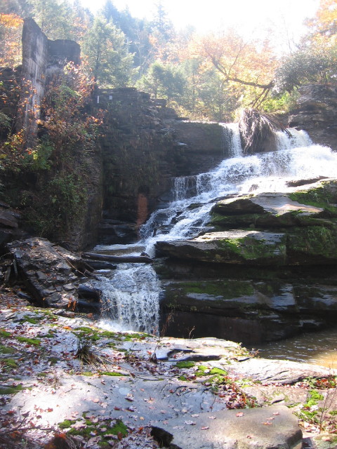
Beginning from the old Woolsey
powerhouse dam, just outside of the Manor, there are at present eight
bridges that cross over the Cattail Brook. These include two bridges on
the county road, four bridges on town streets and two private crossings.
These eight bridges are on a stretch of river, from the dam to where the
Cattail empties into the Willowemoc, that is only about a mile in
length. That is a lot of potential obstacles for such a short stretch of
river.
Aside from the property damage that was caused by the Cattail on the upper section of the village near the old Scudder farm, the downtown flooding from Cattail waters that occurred both recently and in 2006 were the results of one or more of these bridges failure to allow water to pass beneath. Not minimizing the misery and damage caused by the frequent overflow of the Little Beaverkill and Willowemoc, the Cattail flood, as proven by these recent two floods, are more violent and potentially more dangerous. Realizing there are no easy solutions to flooding in the Manor, perhaps a serious discussion by those in charge should be held on the Cattail bridges, the necessity for so many crossings, and their impact the Manor's flooding problem.
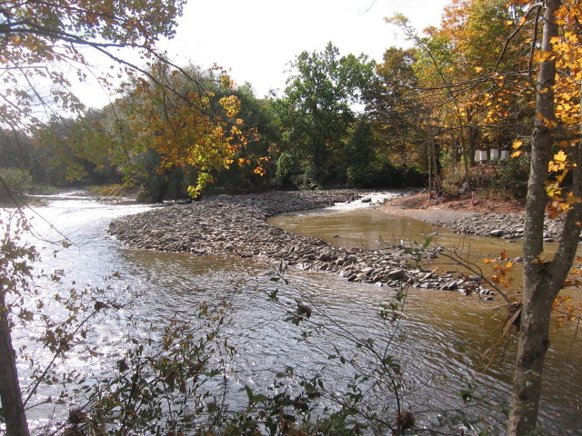
A new gravel bar was created in
the channel of the Willowemoc at the mouth of the Cattail. The mound of
gravel created a dam at the mouth of the Little Beaverkill (not able to
be seen in the photograph because it is behind the gravel) forcing the
latter river to open a new channel and a new confluence with the
Willowemoc, which can be seen on the left side of the photo.
The new Little Beaverkill channel
eliminates the curve in the original channel near where it met the
Willowemoc. This may be a good thing. However, the channel's new
location brings the currents of the Little Beaverkill into the
Willowemoc at more of an angle. During flooding conditions, the volume
of water flowing within the larger river may impede the discharge of the
smaller stream into the former. This may not be a good thing.
It should be noted that the two
recent episodes of flooding along the Cattail, during the years of 2006
and 2012, are not particularly unusual events for that river. What may
be unusual, however, is the length of time that had lapsed between the
2006 flood and the next previous flood, a period of sixty-eight years.
During this long period of uneventful flooding activity, and perhaps
unmindful of the Cattail's history, development had been allowed along
the banks of the Cattail. Some of these residences have been damaged,
some beyond repair, while others appear to be in harms way if, and
probably when, flooding episodes continue.
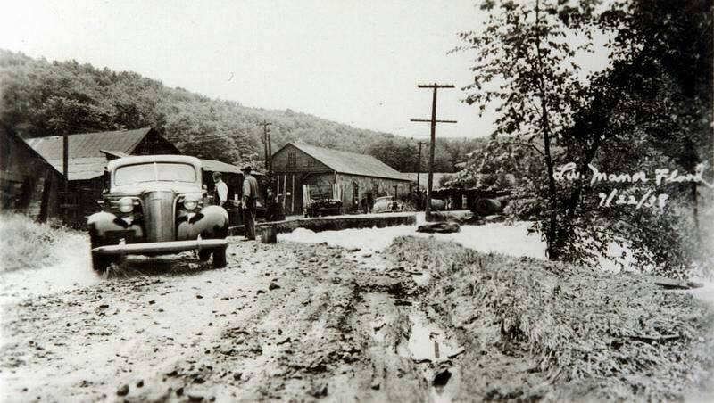
The above photograph shows
flooding along the Cattail in the 1938 flood, the last Cattail flood
event documented until the recent episodes. The scene is in front of the
old acid factory, now the location of the Sullivan County Department of
Public Works. As can be seen, the Shandelee Road has been washed away.
Since the year of this flood, the road has been rebuilt, a new bridge
erected across the Cattail at this same location and six residences
built upstream from the bridge along the riverbank. Resulting from this
year's flood, two of the residences have been condemned and the bridge
washed away.
With all the concern over the
Cattail Brook's recent rampages through Livingston Manor and the
resulting damage inflicted along its course, it should be noted that
this relatively small stream had played an important role in the
development of the village. The first community-wide electric power
franchise was erected south of the village, below the lower falls of the
Cattail.
The Old Homestead Water Company,
begun and operated by P.H. Woolsey and his sons, erected a dam at the
falls in 1907, piping the water from the reservoir to a steam and water
plant below. This operation became known as the Livingston Manor
Electric Company and eventually served the Manor and eight other
communities in the area. In 1924, the plant was sold by the Woolseys to
the New York Gas & Electric Company.
Though not used in supplying water
for the generation of electricity, the power-house dam on the Cattail
still stands. It is, however, slowly wasting away. With each succeeding
flood event, more and more of the concrete structure disappears into the
rapids. Pieces of concrete, presumably from the dam with some chunks as
large as a medicine ball, can be found in the stream bed well over a
half mile downstream from the dam. The recent flood was particularly
destructive to the remaining portion of the dam.
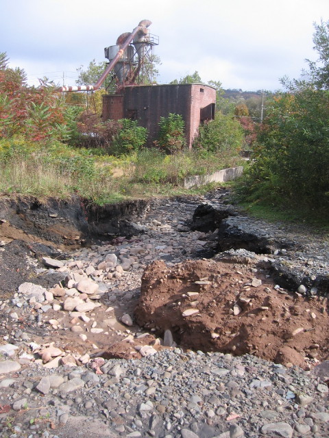
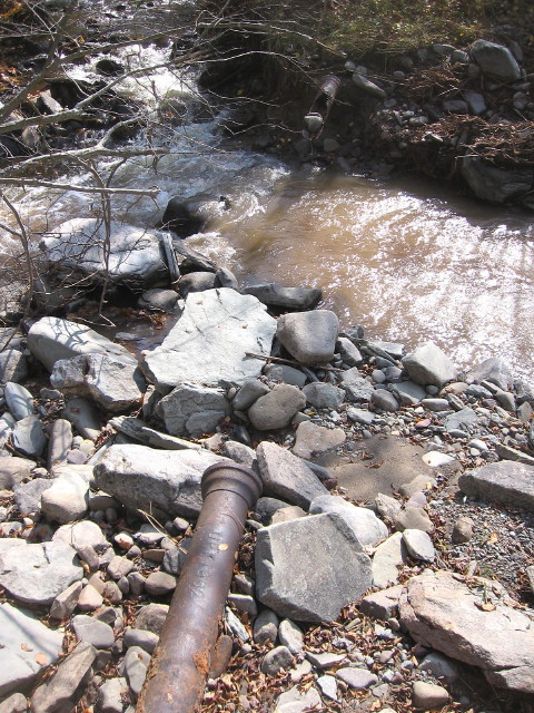
Below the site of the powerhouse,
where the Houghtaling Brook enters the Cattail, sections of pipe used by
the Old Homestead Water Company has been exposed along the banks of the
Cattail. The original village water system, established in 1891,
consisted of small reservoirs built at springs located on the William
Hartig and Garret Rose farms, as well as a reservoir erected on the
Houghtaling Brook [the brook that follows what is now known as the
Cattail Road]. The pipe exposed along the Cattail Brook was the feed
from the Houghtaling Brook reservoir. The date inscribed onto the pipe
is 1902.
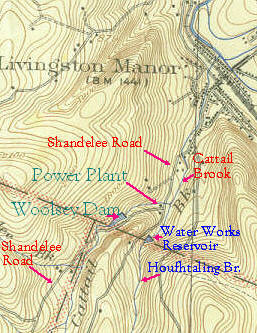
Above is the USGS map, Livingston
Manor quadrangle, dated 1923. I've noted the location of the Livingston
Manor Electric Company's power plant, which no longer exists due to the
reconfiguration of the Shandelee Road, as well as the dam and reservoir
upstream that supplied water for the plant.
Also noted is the location of Houghtaling Brook and the location of the dam and reservoir that served the Livingston Manor Water Company and later the Old Homestead Water Company. The road alongside Houghtaling Brook would be the Cattail Road.
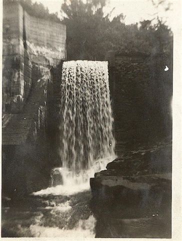
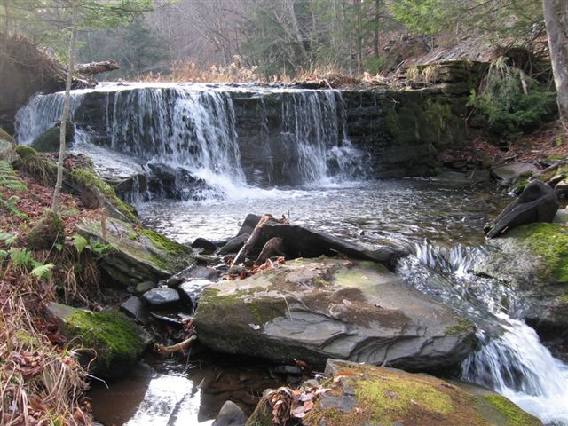
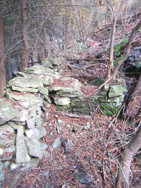
The Old Homestead Water
Company's reservoir on the Houghtaling Brook.
1924, the plant was sold by the Woolseys to the New York Gas & Electric Company.
The footprints of Livingston
Manor history still can be found at the Woolsey power plant location
along the Cattail. Below the dam, numerous stone columns used to
cradle the large pipe that fed water from the dam to the power plant
below still exist. The site of the plant, however, has been destroyed,
buried beneath fill during the construction of the current location of
the Shandelee Road.
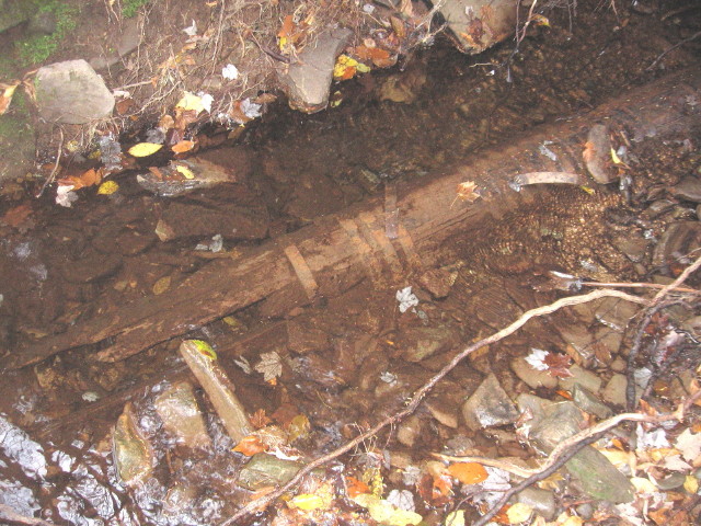
The bottom of the old dam at the
Houghtaling Brook reservoir show numerous portals in which iron pipes
protrude which were used to send the reservoir's water to the village
water system. One particularly interesting pipe, near the edge of the
dam, is a conduit made out of wood; the pipe made up of wooden staves
held together by metal bands.
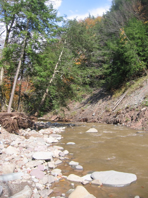
Below the Woolsey power-house dam,
the Cattail Brook's banks are made up of glacial deposited material. As
the river erodes it banks during this half mile stretch, it undermines
the steep slopes, sending soil, rocks and vegetation into the water.
This section is the source of both the river gravel that chokes the
stream bed as well as the trees and debris that get stuck upon the
village bridges.
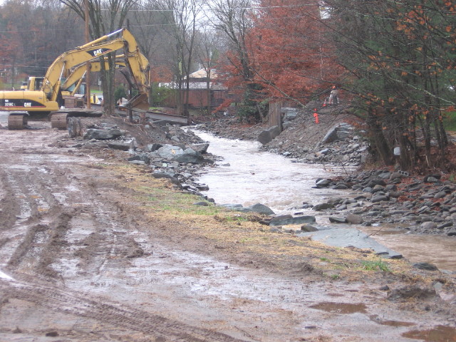
The Cattail Brook is being put
back together. Town, county and state workers along with private
contractors are working on repairing the broken water mains, fixing the
washed out portions of the town highways, shoring up the river's banks
and repairing or replacing the damaged bridges along the one half mile
stretch of river that suffered the most extensive damage during the
September flood.
In discussing the aftermath of the
recent flood events on the Cattail Brook, it really boils down to what
works and what doesn't. As mentioned earlier, there are eight bridges
that cross the Cattail from below the old power-house dam to the streams
confluence with the Willowemoc. Some of these bridges have created
problems while others have not. Shown in the attachment is the bridge on
the Shandelee Road, located above the series of town bridges and private
crossings. The opening underneath this bridge is spacious enough to
allow debris to pass through. Unfortunately, this debris often gets hung
up downstream.
On the downstream side of the
Shandelee Road bridge, there is a bend in the river as the Cattail now
heads toward the village. Due to development along the river's banks
downstream, as well as the continual placing of rip-rap along the banks
to confine the stream into its channel, the channel itself has become
narrowed. This has two effects. As the river approaches the narrow
sections, the water backs up and is slowed down. With this decrease in
speed, the river is no longer able to transport the gravel that is
migrating along the river bed, resulting in the gravel bank shown in the
attachment. Since there is now not a real defined river channel in this
location, any event, even relatively minor events, now sees water flow
on top of the gravel bank resulting in the continual erosion of the lawn
and threatening the residence.
The second effect is that the
velocity of the stream in the narrowed section of the channel increases.
With this increase in velocity is also the increase in the streams
ability to erode. This becomes evident after each major flood by
observing how many of the large stones that have been placed along the
river's banks not only fall into the stream bed, but are actually
transported downstream.
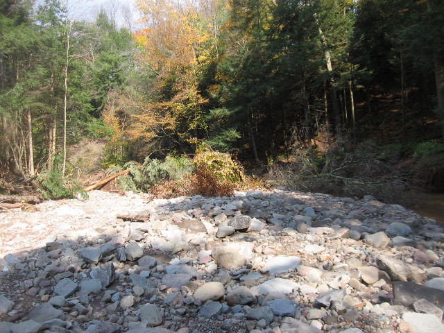
Above the Shandelee Road bridge,
the Cattail already has debris lying in its channel left over from the
recent flood. This has nowhere to go but downstream.
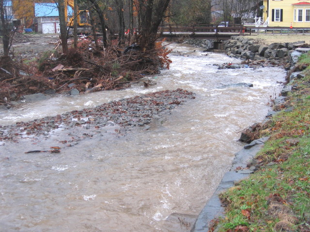
In both of the recent floods along
the Cattail, a dam of debris formed at the Finch Street bridge, sending
floodwaters both onto Main Street and into the village as well as onto
Finch and Willoughby streets. Due to the water being backed up by the
dam, a gravel bank has been formed. In the past, before these floods,
the river channel was at least six feet below the top of its banks. As
can be seen in the attachment, it is considerably less today.
The Finch Street Bridge has been a
problem in the past, and remains so. For whatever reason, the abutment
on the Main Street side of the bridge protrudes beneath the bridge some
four feet into the river channel, restricting the size of the passageway
beneath the bridge. Adding to this potential problem, the stones that
were relaid on the river bank are set to line up with the portion of the
abutment that juts into the river bed, thus further narrowing the
opening underneath the bridge. This stonework along the bank also
narrows the river channel as it approaches the bridge, creating a funnel
effect. How this will all play out with the approaching storm remains to
be seen.
The Flood of 1950"Saturday's hurricane and storm which swept over most of
the nation caused unusual havoc in this area and early estimates of losses
approximately $25,000 in Livingston Manor alone. Winds of gale like
intensity pounded this area starting early Friday night and continued with
unabated violence throughout Saturday, mingled with a heavy rain which
drove streams over their banks Saturday afternoon. "....Main Street merchants suffered
considerable losses. Probably the Nelson Grocery was the hardest hit,
where stock estimated at several thousand dollars was destroyed. Mr.
Nelson said that he had not expected the water to bother him much as he
had experienced floods before which never had gone into the store. In
about an hour his cellar was filled and water was over the floor. Mr.
Neslon was rescued by firemen. "....Others sustaining flood loss
were Vredenburgh's store, unestimated; Manor Theater, $300; Rose Hardware,
$200; United Cigar Store, $300, Russell Funeral Chapel, several hundred
dollars. "....One large tree at the height of the storm fell
across upper Main street, and trees were uprooted all over town, some of
them measuring several feet through the trunk. Louis DuBois, local coal
dealer lost a part of the roof on his coal shed and other damages. "With electric service restored to
most of the Liberty District areas where major interruptions occurred
during last weekend's storm of hurricane proportion, emergency crews of
the New York State Electric & Gas Corporation are concentrating on repairs
and service restoration to scattered locations.
|